
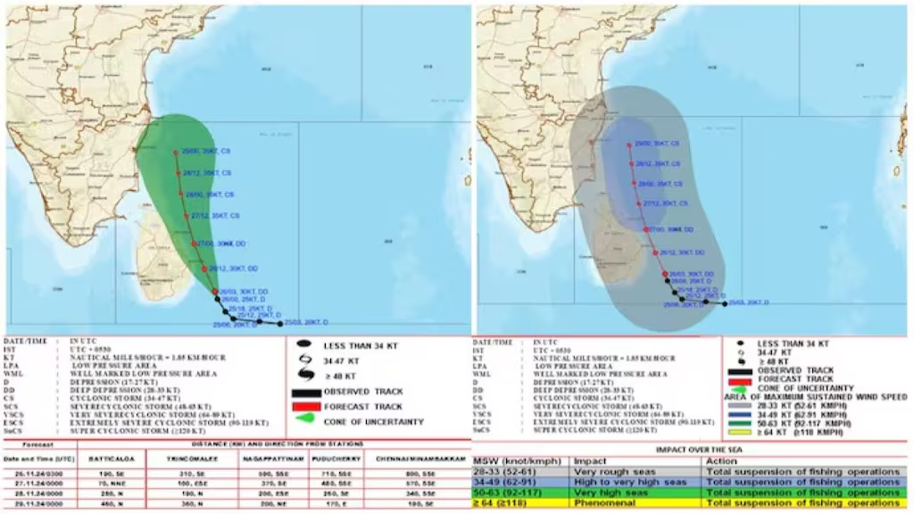
Chennai: “Good cloud formations have formed in the western part of the deep depression. Winds are moving into the clouds from the eastern part. Due to this, we expect it to develop into a cyclone. The area where it will cross the coast has not been estimated yet. As per the current situation, it may settle parallel to the coast, about 150 to 200 km away. We are continuously monitoring it,” said Balachandran, Southern Region Chief of the India Meteorological Department.
Balachandran, Southern Region Chief of the India Meteorological Department, met the media today (Nov.26). He said: “The depression in the Bay of Bengal has strengthened into a deep depression. Following this, it may move in a west-northwesterly direction tomorrow (Nov.27) and strengthen into a cyclone. It may then move towards the coastal areas of Tamil Nadu. Due to this, rains may continue in the coastal areas of Tamil Nadu. For the next 24 hours, heavy to very heavy rainfall (red alert) may occur at one or two places in the districts of Mayiladuthurai, Thiruvarur, Nagapattinam and Karaikal.
Heavy to very heavy rainfall may occur at one or two places in the districts of Tiruvallur, Kanchipuram, Chennai, Chengalpattu, Villupuram, Puducherry, Cuddalore, Ariyalur, Thanjavur, Pudukkottai, Sivaganga and Ramanathapuram. On November 27, very heavy rainfall may occur at one or two places in Cuddalore and Mayiladuthurai districts and heavy to very heavy rainfall may occur at one or two places in the northern coastal districts from Thiruvallur to Pudukkottai.
On Nov. 28, there is a possibility of heavy to very heavy rainfall at one or two places in Tiruvallur, Kanchipuram, Chengalpattu and Villupuram districts and heavy rainfall at one or two places in Tiruvannamalai, Kallakurichi and Cuddalore districts. On Nov. 29, there is a possibility of heavy rainfall at one or two places in Tiruvallur, Chennai, Kanchipuram and Chengalpattu districts.
From today (Nov. 26) to the 30th, fishermen are advised not to venture into the Kumarikadal, Gulf of Mannar, areas adjacent to the Tamil Nadu coast, central West Bay of Bengal and southwest Bay of Bengal as cyclones are likely to occur in these areas.
On Nov. 27 and Nov. 28, the wind speed may reach 70 to 80 kmph in the central West Bay of Bengal adjacent to the southwest Bay of Bengal and at times 90 kmph. These days, the land wind may blow at a speed of 40 to 50 kmph. Fishermen in the deep sea are advised to return to the shore. Regarding the northeast monsoon, the amount of rainfall recorded in Tamil Nadu, Puducherry and Karaikal during the period from October 1 to today is 328 mm. The normal amount for this period is 337 mm. The rainfall has been in line with the normal.
Good cloud formations have formed in the western part of the deep depression. Winds are moving into the cloud formations from the eastern part. Due to this, we expect it to develop into a storm. The area where it will cross the coast is not yet estimated. As per the current situation, it may settle parallel to the coast, about 150 to 200 km away. We are continuously monitoring it.
If the sea temperature is up to 28 degrees Celsius, it is a favorable condition. Similarly, the accumulation and expansion of air are also important. When this air accumulation and expansion are in the same straight line, there is a high chance of forming a storm. The area where the wind direction changes, that is, the speed and direction of the wind are in a favorable environment, has a chance of forming into a storm. At the same time, the area where the storm will cross the coast is not yet predicted,” he said. | Read > Storm forming: Very heavy rain warning for 10 districts in Tamil Nadu on Wednesday
Leave a Reply